Conducting Historical Research to Find Virgin Metal Detecting Sites
by H.Charles Beil
Using historical maps, aerial photographs, field examinations, title searches, and archived and published documents, treasure hunters and historians trace the background of important sites. These include public and private lands, stagecoach trails, roadways, Indian reservations, water sources, and historic travel corridors.
Online databases have become one of the keys to retrieving information provided by others, who maintain personal databases to organize the information they have collected during their research.
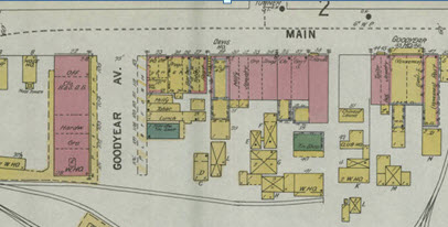
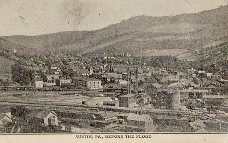
One evening quite late, one of my team from the American Ghost Town Hunters called on the phone to inform me that he had found an undocumented ghost town. The excitement was evident in his voice as he exclaimed “and I did it using those old maps from that website you told me about on the internet”; Thanks. Which old maps website? Now, I was curious. I use a lot of historical map websites in my background research before I actually enter the field to try to locate a town, historic site or treasure cache. I wanted to know which ones. What kind of maps did you use? I queried. He explained how he’d used the digital Sanborn and Beers map database on a Public Library’s website to identify a location in the mountains in Northern Pennsylvania where a village once existed.
The village was now on State land, remote, and probably had never been hunted by a metal detectorist. He printed out a copy of the Beers map from the late 1800s and measured the distance from the village to a stream. Then he measured the distance from the village boundary to the edge of a road; triangulating the village coordinates. Using this information, I organized a trip into the mountains in search of the site. Within a few hours of hiking; success! There among the trees were the foundations of homes that may not have been seen for 150 years. I went on to supervise the documentation, photography and artifact recovery at this site later that year. The finds were significant enough to make it into a magazine.
Any of us interested in heritage conservation, historic preservation or treasure hunting need to be aware of the myriad ways the internet can be used to collect information on the sites that we are seeking. Every day, thousands of historical documents, maps, files, and photographs are uploaded to the internet. These references are making it easier to conduct background research and learn more about our project areas. The problem is, we often want to hit the field before we have fully explored our resources. Putting boots on the ground before conducting thorough research is the bane of all amateur treasure hunters. This generally leads to a wild goose chase for a site that is just no longer there; maybe it was strip mined or to getting caught up in a treasure hoax for something that was never there to begin with.
The difficulty of this process is that these internet sources are often times victims of their own success. As digital information proliferates, a huge pile of data is created that is even more difficult to sift through. In order to make our online historical research more successful, we’ve got to prioritize and establish a process for ourselves; picking the most fruitful yields first and, later, following up with the less necessary sources as time permits. However, it must be noted that nothing that I have found online replaces the quality of the information that is archived in the local historical societies and libraries. It is best to join a large library such as the Carnegie Library in Pittsburgh, University libraries and local historical societies in your area of interest. What online resources can do is to provide quick access to information and expedite the discovery of new places to hunt. This archive is always open for those nights when you just cannot sleep. Here are eight resources I use for efficient online historical research.
- Google Earth – It’s a free atlas of the entire earth.You can digitize polygons, measure distances, calculate UTM coordinates, create your own maps, and zoom in to street level in cities in order to get an excellent idea of what the ground surface looks like today.
- 2) GLO Records – There are two ways any American can become immortal: pay taxes or buy property. The Bureau of Land Management (BLM) has digitized its General Land Office (GLO) records and they are now available online. The BLM-GLO website has most of the records for when land west of the Appalachian Mountains was assumed from the public domain for private ownership (Sorry easterners. You probably can’t use this source very often). Private ownership usually indicates when the historical-period began in a given location. The website also has the original surveyor’s notes and maps, which is most helpful for recreating the landscape before it was developed. The only drawback: you have to know the township and range for the parcel you’re looking for.
- Township and Range Grid for Google Earth – In order to solve the aforementioned problem with Google Earth, Earth Point has created a free township and range plugin. You can use this to figure out the township and range information for your project area and use that info to figure out when it was purchased from the Federal government. Note: This only works for places that were surveyed by the Cadastral Land Survey. It won’t be accurate for places that were surveyed before the GLO or that were part of Spanish or Mexican land grants.
- Local Assessor’s Records – (depends on where you’re working)- Like I mentioned earlier, paying taxes is one of the surest ways to become immortal. And the county assessor is always keeping track of who’s paying their taxes. Unfortunately, the quality of information on the assessor’s website varies from place to place. Some counties have ownership and valuation information for the last dozen property owners. Other counties don’t even have this info online. Also, some assessor’s websites require you to know the tax parcel number, which you may not have.
- Google Books -This resource is like a super library of historical references, many of which are available for free. Instead of immediately going down to your local university’s special collections library, you can check out Google Books which usually has dozens of historical references that are past their copyright. A word of warning: You can waste a bunch of time finding and downloading crappy, outdated information on Google Books. Also, this doesn’t replace actually going to special collections and doing real archival research to find documents that haven’t been digitalized.
- Online Digital Archives- Many cities, counties, and states have online digital repositories that you should check out before you go out to the field. Some good examples include the City of Tucson’s Historic Properties Map , the Arizona Memory Project , and the Washington State Digital Archives . The Seattle Public Library and many other repositories offer free access to their Digital Archives, which includes almost every Sanborn map in the United States! Check out this PDF list of Sanborn Maps <https://geo-search.com/services/historical-products-services/> created by Scott Davis of GeoSearch or http://www.libraries.psu.edu/psul/digital/sanborn.html
Sometimes you will need a valid library card and a reciprocal agreement between your local library and these online libraries.
- Library Special Collections What’s better than looking at digital copies of historical books and documents? Perusing real historical books at universities and public libraries. Whenever possible, I allow at least half a day to look at references at a local university or public library’s special collections. Why do I consider this a means of online research? Because you have to spend time online looking up the references you need. This is best done before you visit the repository so you are not wasting time fumbling with books that will not suit your purpose. However, archival research at special collections isn’t for everyone. It can be boring and tedious. And it takes some planning and preparation beforehand. You need to know the hours of operation, rules for proper conduct, and prices; yes, some archives charge by the hour and ALL charge for copies and scans. This is one way that libraries earn money; somebody has to pay the librarians. You also need to be intimately familiar with the repository’s copyright rules and prices for re-publishing archived images and information. It’s also an excellent idea to call before you go and POLITELY talk to the archivists. Ask them to set aside materials for you and schedule a time to look at them. These folks are generally very busy and under staffed and may take offense if you just drop in and expect them to drop everything that they were working on to help you.
- Historical Photographs – A picture speaks a thousand words; as the saying goes. But where do we find those historic images; in the digital archives of course. http://www.whatwasthere.com
These eight resources are by no means the only historical data sources available on the internet. Whenever I’m the one doing this research, I start with Google Earth (with the township and range plugin), go to the BLM-GLO records, and then move on to Google Books. I also check out the digital Sanborns, Beers and Railroad Maps. If I have a whole day for online archival work, I’ll also check out the county assessor’s records and see what the local library has in special collections. Maybe there’ll be something worth going down to the library to look at. If you’re willing to spend money, there are even more resources and a bunch of apps. You can also pay someone else to do the research if the site that you are looking for appears to be really worthwhile.
The internet brings a wealth of information to our finger tips. All we have to do is point, click and grab it. I would really love to hear from you. If you have any questions or comments, please post them below or send me an email; and do me a favor, if this article was helpful please share it on facebook or twitter that way I’ll be able to keep bringing you useful information to make more and better metal detecting finds.
Recent Comments